
Anger topographic map
Interactive map
Click on the map to display elevation.
About this map
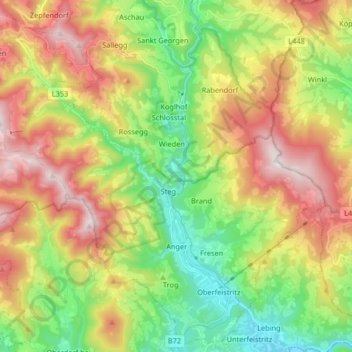
Name: Anger topographic map, elevation, terrain.
Location: Anger, Bezirk Weiz, Styria, 8184, Austria (47.24344 15.59479 47.34994 15.75878)
Average elevation: 790 m
Minimum elevation: 429 m
Maximum elevation: 1,271 m
Other topographic maps
Click on a map to view its topography, its elevation and its terrain.
Plenzengreith
Austria > Styria > Bezirk Weiz
Plenzengreith, Passail, Bezirk Weiz, Styria, 8162, Austria
Average elevation: 946 m
Naas
Austria > Styria > Bezirk Weiz > Naas
Naas, Bezirk Weiz, Styria, 8160, Austria
Average elevation: 745 m
Rosenkogel
Austria > Styria > Bezirk Weiz > Puch bei Weiz
Rosenkogel, Puch bei Weiz, Bezirk Weiz, Styria, 8182, Austria
Average elevation: 542 m