
Plenzengreith topographic map
Interactive map
Click on the map to display elevation.
About this map
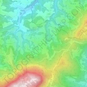
Name: Plenzengreith topographic map, elevation, terrain.
Location: Plenzengreith, Passail, Bezirk Weiz, Styria, 8162, Austria (47.19788 15.45930 47.23788 15.49930)
Average elevation: 946 m
Minimum elevation: 689 m
Maximum elevation: 1,448 m
Other topographic maps
Click on a map to view its topography, its elevation and its terrain.
Fischbach
Austria > Styria > Bezirk Weiz
Fischbach is a town in the Fischbacher Alpen and is located about 12 km (7.5 mi) northwest of Birkfeld and about 27 km (17 mi) air-line distance from the district capital Weiz. The maximum north-south extension as well as the maximum east-west extension are each about nine kilometers (5.6 mi). The municipality…
Average elevation: 1,024 m