
Karlshuld topographic map
Interactive map
Click on the map to display elevation.
About this map
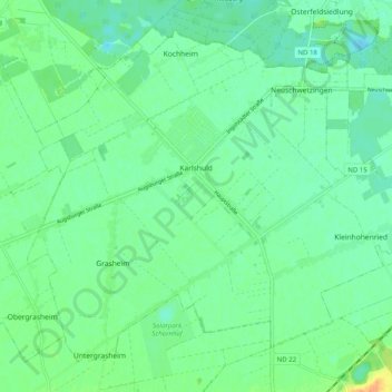
Name: Karlshuld topographic map, elevation, terrain.
Average elevation: 377 m
Minimum elevation: 367 m
Maximum elevation: 400 m
Other topographic maps
Click on a map to view its topography, its elevation and its terrain.
Schrobenhausen
Deutschland > Bayern > Landkreis Neuburg-Schrobenhausen
Schrobenhausen, Landkreis Neuburg-Schrobenhausen, Bayern, 86529, Deutschland
Average elevation: 425 m
Neuburg an der Donau
Deutschland > Bayern > Landkreis Neuburg-Schrobenhausen
Neuburg an der Donau, Landkreis Neuburg-Schrobenhausen, Bayern, 86633, Deutschland
Average elevation: 413 m
Ludwigsmoos
Deutschland > Bayern > Landkreis Neuburg-Schrobenhausen
Ludwigsmoos, Königsmoos, Landkreis Neuburg-Schrobenhausen, Bayern, 86669, Deutschland
Average elevation: 381 m