
Planina Donja topographic map
Interactive map
Click on the map to display elevation.
About this map
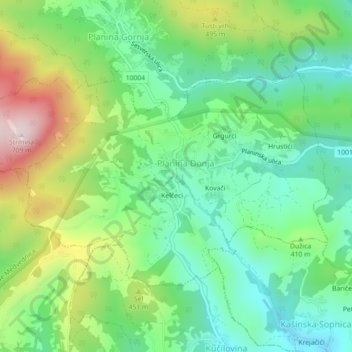
Name: Planina Donja topographic map, elevation, terrain.
Location: Planina Donja, City of Zagreb, Croatia (45.91633 16.06156 45.93572 16.10605)
Average elevation: 374 m
Minimum elevation: 212 m
Maximum elevation: 689 m
Other topographic maps
Click on a map to view its topography, its elevation and its terrain.
Zagreb
Zagreb (/ˈzɑːɡrɛb, ˈzæɡrɛb, zɑːˈɡrɛb/ ZAH-greb, ZAG-reb, zah-GREB, Croatian: [zǎːɡreb] (listen)) is the capital and largest city of Croatia. It is in the northwest of the country, along the Sava river, at the southern slopes of the Medvednica mountain. Zagreb stands near the international…
Average elevation: 249 m