
Saint-Lieux-Lafenasse topographic map
Interactive map
Click on the map to display elevation.
About this map
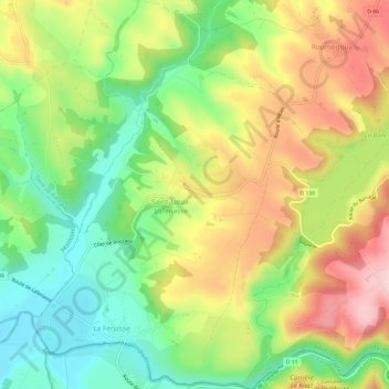
Name: Saint-Lieux-Lafenasse topographic map, elevation, terrain.
Average elevation: 292 m
Minimum elevation: 194 m
Maximum elevation: 411 m
Saint-Lieux-Lafenasse est située au nord-ouest de la montagne Noire, relief qui constitue l'extrémité méridionale du Massif central. La superficie de la commune est de 1 219 hectares. L'altitude de Saint-Lieux-Lafenasse varie entre 197 et 365 mètres.
Other topographic maps
Click on a map to view its topography, its elevation and its terrain.
Le Trivalou
France > Occitanie > Tarn > Terre-de-Bancalié > Le Trivalou
Le Trivalou, Terre-Clapier, Terre-de-Bancalié, Albi, Tarn, Occitanie, France métropolitaine, 81120, France
Average elevation: 368 m
Ronel
France > Occitanie > Tarn > Terre-de-Bancalié
Ronel, Terre-de-Bancalié, Albi, Tarn, Occitanie, France métropolitaine, 81120, France
Average elevation: 290 m