
Deerhurst topographic map
Click on the map to display elevation.
About this map
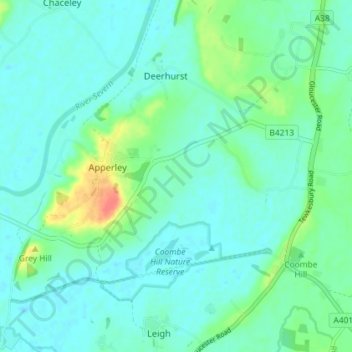
Name: Deerhurst topographic map, elevation, terrain.
Average elevation: 16 m
Minimum elevation: 6 m
Maximum elevation: 53 m
Gloucestershire trails, hiking, mountain biking, running and outdoor activities
Other topographic maps
Click on a map to view its topography, its elevation and its terrain.
Bamfurlong
United Kingdom > England > Gloucestershire > Tewkesbury > Staverton
Average elevation: 34 m
Alney Island
United Kingdom > England > Gloucestershire > Tewkesbury > Maisemore
Average elevation: 13 m
Bishop's Cleeve
United Kingdom > England > Gloucestershire > Tewkesbury > Gotherington
Average elevation: 51 m
Little Shurdington
United Kingdom > England > Gloucestershire > Tewkesbury > Bentham
Average elevation: 112 m
Lower Apperley
United Kingdom > England > Gloucestershire > Tewkesbury > Apperley
Average elevation: 16 m
Wood Stanway
United Kingdom > England > Gloucestershire > Tewkesbury > Stanway
Average elevation: 171 m