
Make a donation
Gear up for your next adventure:
As an Amazon Associate, this site earns from qualifying purchases at no extra cost to you.
Kuala Terengganu topographic map
Click on the map to display elevation.
Make a donation
Gear up for your next adventure:
As an Amazon Associate, this site earns from qualifying purchases at no extra cost to you.
Kuala Terengganu
As a part of Terengganu, Kuala Terengganu has a tropical rainforest climate under the Köppen climate classification (Af) with constant temperature and high humidity. The amount of rainfall varies according to the monsoon season. It is generally fairly hot and humid all year round, averaging from 28 °C to 30 °C in daytime and slightly cooler after dusk. Nevertheless, the sea breeze from South China Sea hsomehow moderates the humidity in offshore areas while the altitude and lush forest trees and plant has cooled the mountain and rural areas.
Make a donation
Gear up for your next adventure:
As an Amazon Associate, this site earns from qualifying purchases at no extra cost to you.
About this map
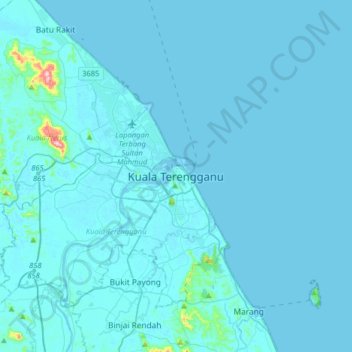
Name: Kuala Terengganu topographic map, elevation, terrain.
Location: Kuala Terengganu, Terengganu, 20300, Malaysia (5.16965 102.97833 5.48965 103.29833)
Average elevation: 9 m
Minimum elevation: -1 m
Maximum elevation: 320 m
Make a donation
Gear up for your next adventure:
As an Amazon Associate, this site earns from qualifying purchases at no extra cost to you.
Other topographic maps
Click on a map to view its topography, its elevation and its terrain.
Duyung Small Island
Malaysia > Terengganu > Kuala Terengganu > Kuala Terengganu
Average elevation: 4 m
Pak Mat Lebai Island
Malaysia > Terengganu > Kuala Terengganu > Kuala Terengganu
Average elevation: 6 m
Make a donation
Gear up for your next adventure:
As an Amazon Associate, this site earns from qualifying purchases at no extra cost to you.
Batu Burok Public Park
Malaysia > Terengganu > Kuala Terengganu > Kuala Terengganu
Average elevation: 5 m
Make a donation
Gear up for your next adventure:
As an Amazon Associate, this site earns from qualifying purchases at no extra cost to you.
Taman Tamadun Islam (Mini Islam)
Malaysia > Terengganu > Kuala Terengganu > Kuala Terengganu
Average elevation: 5 m