Geolocate

Baladiya topographic map

Click on the map to display elevation.

About this map

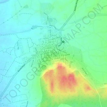
Name: Baladiya topographic map, elevation, terrain.

Location: Baladiya, Bhuj Taluka, Kachchh, Gujarat, 370427, India (23.09446 69.61088 23.09796 69.61418)

Average elevation: 155 m

Minimum elevation: 132 m

Maximum elevation: 205 m

Other topographic maps

Click on a map to view its topography, its elevation and its terrain.

Khavda

India > Gujarat > Bhuj Taluka

Average elevation: 14 m

Dhrobana

India > Gujarat > Bhuj Taluka

Average elevation: 40 m

Dhordo

India > Gujarat > Bhuj Taluka

Average elevation: 4 m

Sedata

India > Gujarat > Bhuj Taluka

Average elevation: 180 m

Kachchh

India > Gujarat > Bhuj Taluka

Average elevation: 3 m

Amrapar (2)

India > Gujarat > Bhuj Taluka

Average elevation: 15 m

Gear up for your next adventure:

👟Men's Trail Running Shoes - Lightweight grip for fast movement over topographic contours
📷Camera Straps - Secure straps for carrying cameras while walking
Insulated Travel Mugs - Keep drinks hot while surveying the landscape from a summit
📸Action Camera Chest Mounts - Record your ascent following topographic paths hands-free
🛰️Outdoor GPS Navigation - Navigation devices for remote and off-grid areas

As an Amazon Associate, this site earns from qualifying purchases at no extra cost to you.