Geolocate

Kiserian topographic map

Click on the map to display elevation.

About this map

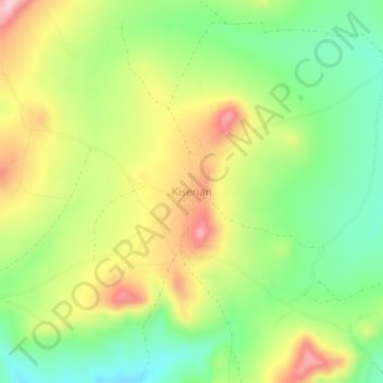
Name: Kiserian topographic map, elevation, terrain.

Location: Kiserian, Longido, Arusha, Northern Zone, Tanzania (-2.86865 36.50822 -2.82865 36.54822)

Average elevation: 1,588 m

Minimum elevation: 1,493 m

Maximum elevation: 1,710 m

Other topographic maps

Click on a map to view its topography, its elevation and its terrain.

Arusha

Tanzania > Arusha

Average elevation: 1,277 m

Karatu

Tanzania > Arusha

Karatu District (Wilaya ya Karatu, in Swahili) is one of seven districts of the Arusha Region of Tanzania. The district is bordered to the north by the Ngorongoro District and to the west by the Meatu District in the Simiyu Region. The district is bordered to the east by the Monduli District, and to the south…

Average elevation: 1,468 m

Ngorongoro Crater

Tanzania > Arusha

Average elevation: 1,963 m

Meru

Tanzania > Arusha

Average elevation: 1,342 m

Arusha

Tanzania > Arusha

Average elevation: 1,349 m

Oldupai Gorge

Tanzania > Arusha

Average elevation: 1,494 m

Gear up for your next adventure:

📢Survival Whistles - Essential safety gear for signaling for help in mountain fog
🛑Emergency Bivvy Bags - Heat-reflective survival bags for unexpected nights out
🗺️Scratch-off Peak Maps - Track your progress climbing Munros or Wainwrights
📷Outdoor Action Cameras - Cameras designed for hiking and adventure
👟Men's Trail Running Shoes - Lightweight grip for fast movement over topographic contours

As an Amazon Associate, this site earns from qualifying purchases at no extra cost to you.