Geolocate

Arusha topographic map

Click on the map to display elevation.

About this map

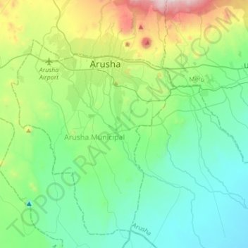
Name: Arusha topographic map, elevation, terrain.

Location: Arusha, Northern Zone, Tanzania (-3.57321 36.59996 -3.29941 36.80450)

Average elevation: 1,277 m

Minimum elevation: 957 m

Maximum elevation: 2,325 m

Other topographic maps

Click on a map to view its topography, its elevation and its terrain.

Ngorongoro Crater

Tanzania > Arusha

Average elevation: 1,963 m

Laroi

Tanzania > Arusha

Average elevation: 1,175 m

Songoro Ward

Tanzania > Arusha > Mulala

Average elevation: 1,252 m

Kipande Nnkoavele

Tanzania > Arusha

Average elevation: 1,640 m

Bangata Ward

Tanzania > Arusha

Average elevation: 1,273 m

Urisho

Tanzania > Arusha

Average elevation: 1,627 m

Longido

Tanzania > Arusha

Average elevation: 1,462 m

Shangarai

Tanzania > Arusha

Average elevation: 1,370 m

Nduruma

Tanzania > Arusha

Average elevation: 1,011 m

Mto wa Mbu

Tanzania > Arusha

Average elevation: 1,019 m

Oldupai Gorge

Tanzania > Arusha

Average elevation: 1,494 m

Usa River

Tanzania > Arusha

Average elevation: 1,197 m

Kiserian

Tanzania > Arusha

Average elevation: 1,588 m

Gear up for your next adventure:

🧥Breathable Waterproof Jackets - Essential rain protection for the unpredictable British climate
📷Camera Straps - Secure straps for carrying cameras while walking
🛌Sleeping Mats - Insulated mats for comfortable outdoor sleeping
🚲Cycling GPS Computers - Track elevation and topographic routes on two wheels
🧢Hiking Hats - Sun and weather protection for outdoor walks

As an Amazon Associate, this site earns from qualifying purchases at no extra cost to you.