
Make a donation
Gear up for your next adventure:
As an Amazon Associate, this site earns from qualifying purchases at no extra cost to you.
Gemeinde Lech topographic map
Click on the map to display elevation.
Make a donation
Gear up for your next adventure:
As an Amazon Associate, this site earns from qualifying purchases at no extra cost to you.
Gemeinde Lech
The altitude of 1444 m for the village refers to the location of the old church on a hill. 14.1% of the municipal area is forested, 58% of the area is Alpine. Geographically and historically, Lech belongs to the Hochtannberg region, formerly Tannberg, but in terms of tourism the municipality is part of the Arlberg region. Lech belongs to the district of Bludenz and also to the judicial district of Bludenz, but unlike its southern neighboring communities of Klösterle and Dalaas, which also belong to the district of Bludenz, it is not located in the Klostertal, but in the Arlberg massif to the northeast of it.
Make a donation
Gear up for your next adventure:
As an Amazon Associate, this site earns from qualifying purchases at no extra cost to you.
About this map
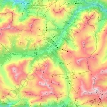
Name: Gemeinde Lech topographic map, elevation, terrain.
Location: Gemeinde Lech, Bezirk Bludenz, Vorarlberg, Austria (47.14803 10.03213 47.25166 10.21375)
Average elevation: 1,947 m
Minimum elevation: 1,164 m
Maximum elevation: 2,782 m
Make a donation
Gear up for your next adventure:
As an Amazon Associate, this site earns from qualifying purchases at no extra cost to you.
Other topographic maps
Click on a map to view its topography, its elevation and its terrain.
Make a donation
Gear up for your next adventure:
As an Amazon Associate, this site earns from qualifying purchases at no extra cost to you.
Zürs
Austria > Vorarlberg > Bezirk Bludenz
Tourism is the main source of income for the town of Zürs. Due to its high altitude (over 2,000m), the landscape is largely free of forest and therefore offers a clear view of the surrounding Alpine peaks. In addition, there is always plenty of snow in the Arlberg region, providing a picturesque setting for…
Average elevation: 2,055 m
Make a donation
Gear up for your next adventure:
As an Amazon Associate, this site earns from qualifying purchases at no extra cost to you.
Brandnertal
Austria > Vorarlberg > Bezirk Bludenz > Brand
The Brandnertal is located in the southern part of Vorarlberg, in the far west of Austria. Adjacent to Switzerland, the Principality of Liechtenstein and Germany. In the immediate vicinity of the city of Bludenz starts the Brandnertal. From Bürs the valley rises, via Bürserberg to Brand, which is at an…
Average elevation: 1,572 m
Zürs
Austria > Vorarlberg > Bezirk Bludenz
Tourism is the main source of income for the town of Zürs. Due to its high altitude (over 2,000m), the landscape is largely free of forest and therefore offers a clear view of the surrounding Alpine peaks. In addition, there is always plenty of snow in the Arlberg region, providing a picturesque setting for…
Average elevation: 2,055 m
Make a donation
Gear up for your next adventure:
As an Amazon Associate, this site earns from qualifying purchases at no extra cost to you.
Make a donation
Gear up for your next adventure:
As an Amazon Associate, this site earns from qualifying purchases at no extra cost to you.