
The Falls topographic map
Interactive map
Click on the map to display elevation.
About this map
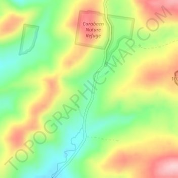
Name: The Falls topographic map, elevation, terrain.
Location: The Falls, Warwick, Queensland, 4370, Australie (-28.32722 152.38471 -28.30722 152.40471)
Average elevation: 952 m
Minimum elevation: 861 m
Maximum elevation: 1,054 m
Other topographic maps
Click on a map to view its topography, its elevation and its terrain.
Mount Steele
Australie > Queensland > Warwick
Mount Steele, Warwick, Queensland, 4370, Australie
Average elevation: 486 m