
Laborie topographic map
Interactive map
Click on the map to display elevation.
About this map
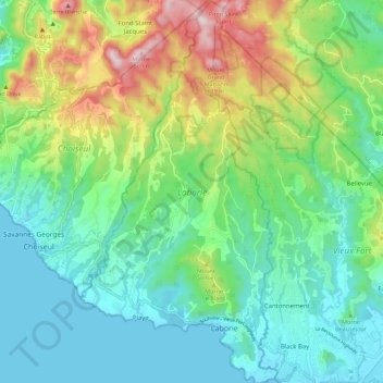
Name: Laborie topographic map, elevation, terrain.
Location: Laborie, Saint Lucia (13.73506 -61.03774 13.84409 -60.97986)
Average elevation: 183 m
Minimum elevation: 0 m
Maximum elevation: 638 m
Other topographic maps
Click on a map to view its topography, its elevation and its terrain.
Beausejour
Beausejour, Gros Islet, LC01 601, Saint Lucia
Average elevation: 32 m
Cas en bas
Saint Lucia > Gros Islet > Beausejour > Windward Hills
Cas en bas, Windward Hills, Beausejour, Gros Islet, Saint Lucia
Average elevation: 29 m
Gros Islet
Saint Lucia > Gros Islet > Gros Islet
Gros Islet, LCO1 101, Saint Lucia
Average elevation: 27 m
Industrial Estate
Saint Lucia > Vieux Fort > Industrial Estate
Industrial Estate, Vieux Fort, LC 11 101, Saint Lucia
Average elevation: 19 m
Soufriere
Saint Lucia > Soufriere > Soufriere
Soufriere, ST. LUCIA, Saint Lucia
Average elevation: 188 m