
Najrah topographic map
Interactive map
Click on the map to display elevation.
About this map
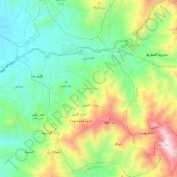
Name: Najrah topographic map, elevation, terrain.
Location: Najrah, Gouvernorat de Hajjah, Yémen (15.60705 43.50664 15.69826 43.58378)
Average elevation: 1,098 m
Minimum elevation: 580 m
Maximum elevation: 2,097 m
Other topographic maps
Click on a map to view its topography, its elevation and its terrain.
الدوحة
الدوحة, Aflah al Yaman, Gouvernorat de Hajjah, Yémen
Average elevation: 1,175 m
Kuhlan Affar
Kuhlan Affar, Gouvernorat de Hajjah, Yémen
Average elevation: 1,628 m
الشرقية
Yémen > Gouvernorat de Hajjah > الشرقية
الشرقية, Washhah, Gouvernorat de Hajjah, Yémen
Average elevation: 631 m