
Qarah topographic map
Interactive map
Click on the map to display elevation.
About this map
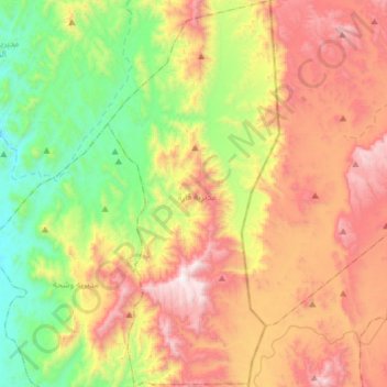
Name: Qarah topographic map, elevation, terrain.
Location: Qarah, Gouvernorat de Hajjah, Yémen (16.26013 43.40825 16.54374 43.53942)
Average elevation: 1,003 m
Minimum elevation: 343 m
Maximum elevation: 1,867 m
Other topographic maps
Click on a map to view its topography, its elevation and its terrain.
الدوحة
الدوحة, Aflah al Yaman, Gouvernorat de Hajjah, Yémen
Average elevation: 1,175 m
Kuhlan Affar
Kuhlan Affar, Gouvernorat de Hajjah, Yémen
Average elevation: 1,628 m
الشرقية
Yémen > Gouvernorat de Hajjah > الشرقية
الشرقية, Washhah, Gouvernorat de Hajjah, Yémen
Average elevation: 631 m