
Beaufort topographic map
Click on the map to display elevation.
About this map
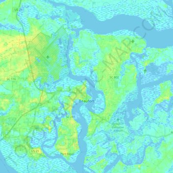
Name: Beaufort topographic map, elevation, terrain.
Location: Beaufort, Beaufort County, South Carolina, United States (32.36589 -80.82735 32.52601 -80.62375)
Average elevation: 4 m
Minimum elevation: -5 m
Maximum elevation: 17 m
Other topographic maps
Click on a map to view its topography, its elevation and its terrain.
Royal Pines Country Club Estates
United States > South Carolina > Beaufort County
Average elevation: 7 m
Hilton Head Plantation
United States > South Carolina > Beaufort County > Hilton Head Island
Average elevation: 6 m
Palmetto Dunes
United States > South Carolina > Beaufort County > Hilton Head Island
Average elevation: 3 m
Hilton Head Island
United States > South Carolina > Beaufort County > Hilton Head Island
Average elevation: 2 m
Sea Pines
United States > South Carolina > Beaufort County > Hilton Head Island
Average elevation: 4 m
Palmetto Dunes
United States > South Carolina > Beaufort County > Hilton Head Island
Average elevation: 3 m
Port Royal
United States > South Carolina > Beaufort County > Hilton Head Island
Average elevation: 3 m
Indigo Run
United States > South Carolina > Beaufort County > Hilton Head Island
Average elevation: 5 m
Morgan River Estates
United States > South Carolina > Beaufort County > Morgan River Estates
Average elevation: 4 m
Hilton Head Plantation
United States > South Carolina > Beaufort County > Hilton Head Island
Average elevation: 6 m