
Make a donation
Gear up for your next adventure:
As an Amazon Associate, this site earns from qualifying purchases at no extra cost to you.
Danvers topographic map
Click on the map to display elevation.
Make a donation
Gear up for your next adventure:
As an Amazon Associate, this site earns from qualifying purchases at no extra cost to you.
Danvers
Though being at sea level in the Danversport area, the town has numerous hills reaching around 130 to 180 feet in elevation, including Dales Hill (located at St. John's Preparatory School), Ferncroft Hill, Folly Hill, Hathorne Hill, Lindall Hill, Nichols Hill, Putnam Hill, Rocky Hill and Whipple Hill (part of Endicott Park).
Make a donation
Gear up for your next adventure:
As an Amazon Associate, this site earns from qualifying purchases at no extra cost to you.
About this map
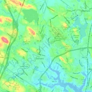
Name: Danvers topographic map, elevation, terrain.
Location: Danvers, Essex County, Massachusetts, United States (42.54016 -71.00281 42.61324 -70.90762)
Average elevation: 23 m
Minimum elevation: -2 m
Maximum elevation: 81 m
Make a donation
Gear up for your next adventure:
As an Amazon Associate, this site earns from qualifying purchases at no extra cost to you.
Other topographic maps
Click on a map to view its topography, its elevation and its terrain.
Make a donation
Gear up for your next adventure:
As an Amazon Associate, this site earns from qualifying purchases at no extra cost to you.
Make a donation
Gear up for your next adventure:
As an Amazon Associate, this site earns from qualifying purchases at no extra cost to you.
Little River Marshes
United States > Massachusetts > Essex County > Gloucester > West Gloucester
Average elevation: 27 m
Freshwater Cove Village
United States > Massachusetts > Essex County > Gloucester
Average elevation: 18 m
Make a donation
Gear up for your next adventure:
As an Amazon Associate, this site earns from qualifying purchases at no extra cost to you.
Blackwater River
United States > Massachusetts > Essex County > Salisbury > Salisbury Beach
Average elevation: 4 m
Make a donation
Gear up for your next adventure:
As an Amazon Associate, this site earns from qualifying purchases at no extra cost to you.
Make a donation
Gear up for your next adventure:
As an Amazon Associate, this site earns from qualifying purchases at no extra cost to you.
Make a donation
Gear up for your next adventure:
As an Amazon Associate, this site earns from qualifying purchases at no extra cost to you.
Make a donation
Gear up for your next adventure:
As an Amazon Associate, this site earns from qualifying purchases at no extra cost to you.
Make a donation
Gear up for your next adventure:
As an Amazon Associate, this site earns from qualifying purchases at no extra cost to you.
Make a donation
Gear up for your next adventure:
As an Amazon Associate, this site earns from qualifying purchases at no extra cost to you.
Kettle Cove Village
United States > Massachusetts > Essex County > Manchester-by-the-Sea
Average elevation: 18 m
Make a donation
Gear up for your next adventure:
As an Amazon Associate, this site earns from qualifying purchases at no extra cost to you.
Make a donation
Gear up for your next adventure:
As an Amazon Associate, this site earns from qualifying purchases at no extra cost to you.
Make a donation
Gear up for your next adventure:
As an Amazon Associate, this site earns from qualifying purchases at no extra cost to you.
Make a donation
Gear up for your next adventure:
As an Amazon Associate, this site earns from qualifying purchases at no extra cost to you.
Make a donation
Gear up for your next adventure:
As an Amazon Associate, this site earns from qualifying purchases at no extra cost to you.
Make a donation
Gear up for your next adventure:
As an Amazon Associate, this site earns from qualifying purchases at no extra cost to you.
Amesbury
United States > Massachusetts > Essex County > Amesbury
Amesbury is located at 42°51′29″N 70°55′50″W / 42.85806°N 70.93056°W / 42.85806; -70.93056. According to the United States Census Bureau, the city has a total area of 13.7 square miles (35.5 km2), of which 12.3 square miles (31.8 km2) is land and 1.5 square miles (3.8 km2), or 10.65%, is…
Average elevation: 24 m
Make a donation
Gear up for your next adventure:
As an Amazon Associate, this site earns from qualifying purchases at no extra cost to you.
East Parish
United States > Massachusetts > Essex County > Boxford > Boxford > East Parish
Average elevation: 38 m