Geolocate

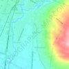
Jodipan topographic map

Click on the map to display elevation.

About this map

Name: Jodipan topographic map, elevation, terrain.

Location: Jodipan, Malang, Klojen, East Java, Indonesia (-7.99327 112.63565 -7.98255 112.64701)

Average elevation: 435 m

Minimum elevation: 405 m

Maximum elevation: 482 m

Other topographic maps

Click on a map to view its topography, its elevation and its terrain.

Tarekot Malang City Park

Indonesia > East Java > Malang

Average elevation: 445 m

Kedungkandang

Indonesia > East Java > Malang

Average elevation: 453 m

Gear up for your next adventure:

🎒Backpack Rain Covers - Universal waterproof covers to protect your gear from downpours
🧢Hiking Hats - Sun and weather protection for outdoor walks
🧥Waterproof Hiking Jackets - Rain protection for walking in all weather conditions
🥤Hydration Bladders - Hands-free hydration systems for backpacks
🦶Anti-Blister Balms - Protect your feet before long topographic expeditions

As an Amazon Associate, this site earns from qualifying purchases at no extra cost to you.