
Tangier topographic map
Click on the map to display elevation.
Tangier
Tangier was formally known as Colonia Julia Tingi ("The Julian Colony of Tingis") following its elevation to colony status during the Roman Empire. The nicknames "Bride of the North" and "Door of Africa" reference its position in far northwestern Africa near the Strait of Gibraltar.
About this map
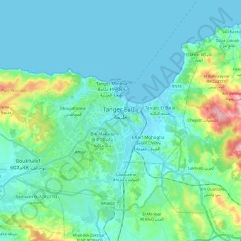
Name: Tangier topographic map, elevation, terrain.
Average elevation: 68 m
Minimum elevation: -1 m
Maximum elevation: 476 m
Other topographic maps
Click on a map to view its topography, its elevation and its terrain.
Dar Barroud
Morocco > Tangier-Tetouan-Al Hoceima > Pachalik de Tanger باشوية طنجة > Tangier
Average elevation: 20 m
Rmilet
Morocco > Tangier-Tetouan-Al Hoceima > Pachalik de Tanger باشوية طنجة > Tanger طنجة
Average elevation: 112 m
Parque del Marxán
Morocco > Tangier-Tetouan-Al Hoceima > Pachalik de Tanger باشوية طنجة > Tangier
Average elevation: 29 m
Mghayer
Morocco > Tangier-Tetouan-Al Hoceima > Pachalik de Tanger باشوية طنجة > Tangier
Average elevation: 93 m