Geolocate

Parc Perdicaris topographic map

Click on the map to display elevation.

About this map

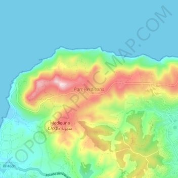
Name: Parc Perdicaris topographic map, elevation, terrain.

Location: Parc Perdicaris, Tangier, Pachalik de Tanger باشوية طنجة, Prefecture of Tangier - Assilah, Tangier-Tetouan-Al Hoceima, Morocco (35.77067 -5.92489 35.80048 -5.84449)

Average elevation: 87 m

Minimum elevation: -2 m

Maximum elevation: 318 m

Other topographic maps

Click on a map to view its topography, its elevation and its terrain.

Gear up for your next adventure:

🔋Solar Chargers - Eco-friendly charging solutions for outdoor use
📐Altimeters & Barometers - Tools for measuring altitude and air pressure
👖Packable Overtrousers - Quick-deploy rain protection for legs in sudden storms
🕶️Glacier Goggles - Maximum protection for high-altitude snow topography
🛰️Outdoor GPS Navigation - Navigation devices for remote and off-grid areas

As an Amazon Associate, this site earns from qualifying purchases at no extra cost to you.