Geolocate

Cork topographic map

Click on the map to display elevation.

About this map

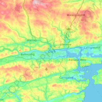
Name: Cork topographic map, elevation, terrain.

Location: Cork, County Cork, Munster, T12 T997, Ireland (51.73708 -8.62547 52.05708 -8.30547)

Average elevation: 94 m

Minimum elevation: -6 m

Maximum elevation: 303 m

Other topographic maps

Click on a map to view its topography, its elevation and its terrain.

Ballintemple

Ireland > County Cork > Cork

Average elevation: 20 m

Cork City North West

Ireland > County Cork > Cork

Average elevation: 68 m

Elizabeth Fort

Ireland > County Cork > Cork

Average elevation: 28 m

Maryborough

Ireland > County Cork > Cork

Average elevation: 51 m

Grange

Ireland > County Cork > Cork

Average elevation: 50 m

Kilcully

Ireland > County Cork > Cork

Average elevation: 83 m

Douglas

Ireland > County Cork > Cork

Average elevation: 34 m

Ballygarvan

Ireland > County Cork > Cork

Average elevation: 104 m

Gear up for your next adventure:

🧤Thermal Touchscreen Gloves - Stay warm while operating your GPS or smartphone camera
🧰Survival Kits - Emergency tools for remote environments
📚UK Hiking Guidebooks - Detailed route descriptions for the Lake District, Peaks, and Highlands
🥤Hydration Bladders - Hands-free hydration systems for backpacks
📷Camera Straps - Secure straps for carrying cameras while walking

As an Amazon Associate, this site earns from qualifying purchases at no extra cost to you.