
Region Westmakedonien topographic map
Interactive map
Click on the map to display elevation.
About this map
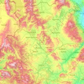
Name: Region Westmakedonien topographic map, elevation, terrain.
Location: Region Westmakedonien, Epirus - Westmakedonien, Griechenland (39.83036 20.77537 40.94346 22.19532)
Average elevation: 938 m
Minimum elevation: 26 m
Maximum elevation: 2,597 m
Other topographic maps
Click on a map to view its topography, its elevation and its terrain.
Aliakmonas
Griechenland > Epirus - Westmakedonien
Aliakmonas, Δήμος Ορεστίδος, Regionalbezirk Kastoria, Region Westmakedonien, Epirus - Westmakedonien, 52057, Griechenland
Average elevation: 642 m
Epirus - Westmakedonien
Griechenland > Epirus - Westmakedonien
Epirus - Westmakedonien, Griechenland
Average elevation: 661 m