
Munster topographic map
Interactive map
Click on the map to display elevation.
About this map
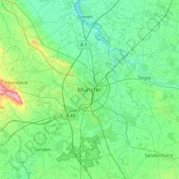
Name: Munster topographic map, elevation, terrain.
Location: Munster, Noordrijn-Westfalen, 48143, Duitsland (51.80251 7.46519 52.12251 7.78519)
Average elevation: 62 m
Minimum elevation: 37 m
Maximum elevation: 192 m
Other topographic maps
Click on a map to view its topography, its elevation and its terrain.
Dortmund-Ems-Kanal
Duitsland > Noordrijn-Westfalen > Munster
Dortmund-Ems-Kanal, Munster, Regierungsbezirk Münster, Noordrijn-Westfalen, 48145, Duitsland
Average elevation: 58 m