
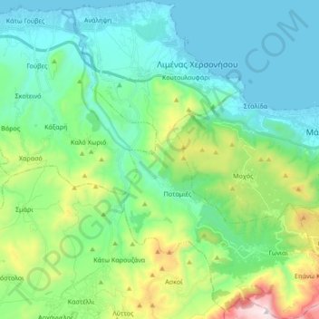
Chersonisos Municipal Unit topographic map
Interactive map
Click on the map to display elevation.
About this map
Name: Chersonisos Municipal Unit topographic map, elevation, terrain.
Average elevation: 267 m
Minimum elevation: -2 m
Maximum elevation: 1,151 m
Other topographic maps
Click on a map to view its topography, its elevation and its terrain.
Malia
Greece > Region of Crete > Heraklion Regional Unit > Malia Municipal Unit
Average elevation: 199 m
Apostoli
Greece > Region of Crete > Heraklion Regional Unit > Kastelli Municipal Unit
Average elevation: 387 m
Archontiko
Greece > Region of Crete > Heraklion Regional Unit > Arkalochori Municipal Unit
Average elevation: 381 m
Kastelli
Greece > Region of Crete > Heraklion Regional Unit > Kastelli Municipal Unit
Average elevation: 366 m
Galia
Greece > Region of Crete > Heraklion Regional Unit > Mires Municipal Unit
It lies at an altitude of 250 metres (820 ft), surrounded by hills. It commands an imposing view south to the Messara Plain and to the Asterousia mountain range, west to the Libyan Sea and north to the Psiloritis mountain. It has 833 residents (2021), mainly farmers.
Average elevation: 227 m
Archanes
Greece > Region of Crete > Heraklion Regional Unit > Archanes Municipal Unit
Average elevation: 333 m
Bethlehem Gate
Greece > Region of Crete > Heraklion Regional Unit > Heraklion Municipal Unit
Average elevation: 32 m
Tris Ekklisies
Greece > Region of Crete > Heraklion Regional Unit > Asterousia Municipal Unit
Average elevation: 223 m
Nea Alikarnassos
Greece > Region of Crete > Heraklion Regional Unit > Nea Alikarnassos Municipal Unit
Average elevation: 30 m
Knossos Palace
Greece > Region of Crete > Heraklion Regional Unit > Heraklion Municipal Unit
The identification of Knossos with the Bronze Age site is supported by the Roman coins that were scattered over the fields surrounding the pre-excavation site, then a large mound named Kephala Hill, elevation 85 m (279 ft) from current sea level. Many of them were inscribed with Knosion or Knos on the obverse…
Average elevation: 151 m
Larani
Greece > Region of Crete > Heraklion Regional Unit > Agia Varvava Municipal Unit
Average elevation: 469 m
Bethlehem Gate
Greece > Region of Crete > Heraklion Regional Unit > Heraklion Municipal Unit
Average elevation: 32 m
Gouves
Greece > Region of Crete > Heraklion Regional Unit > Gouves Municipal Unit
Average elevation: 124 m
Anissaras
Greece > Region of Crete > Heraklion Regional Unit > Chersonisos Municipal Unit
Average elevation: 16 m
Tymbaki
Greece > Region of Crete > Heraklion Regional Unit > Tybakio Municipal Unit
Average elevation: 56 m