
Make a donation
Gear up for your next adventure:
As an Amazon Associate, this site earns from qualifying purchases at no extra cost to you.
Castroville topographic map
Click on the map to display elevation.
Make a donation
Gear up for your next adventure:
As an Amazon Associate, this site earns from qualifying purchases at no extra cost to you.
About this map
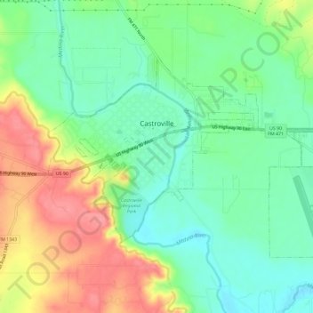
Name: Castroville topographic map, elevation, terrain.
Location: Castroville, Medina County, Texas, United States (29.33486 -98.89896 29.36731 -98.84116)
Average elevation: 249 m
Minimum elevation: 216 m
Maximum elevation: 298 m
Make a donation
Gear up for your next adventure:
As an Amazon Associate, this site earns from qualifying purchases at no extra cost to you.
Other topographic maps
Click on a map to view its topography, its elevation and its terrain.
D'Hanis
United States > Texas > Medina County
D'Hanis is at an elevation of 883 feet (269 m) above sea level.
Average elevation: 273 m
Make a donation
Gear up for your next adventure:
As an Amazon Associate, this site earns from qualifying purchases at no extra cost to you.