
North East Gonja District topographic map
Interactive map
Click on the map to display elevation.
About this map
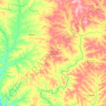
Name: North East Gonja District topographic map, elevation, terrain.
Location: North East Gonja District, Savannah Region, Ghana (8.64696 -0.93644 9.32877 -0.19514)
Average elevation: 146 m
Minimum elevation: 78 m
Maximum elevation: 237 m
Other topographic maps
Click on a map to view its topography, its elevation and its terrain.
Bamboi
Ghana > Savannah Region > Bole District
Bamboi, Bole District, Savannah Region, Ghana
Average elevation: 105 m
Damongo
Ghana > Savannah Region > West Gonja Municipal District
Damongo, West Gonja Municipal District, Savannah Region, Ghana
Average elevation: 205 m
Central Gonja District
Central Gonja District, Savannah Region, Ghana
Average elevation: 139 m
Busunu
Ghana > Savannah Region > West Gonja Municipal District > Busunu
Busunu, West Gonja Municipal District, Savannah Region, Ghana
Average elevation: 142 m
Salaga
Ghana > Savannah Region > East Gonja Municipal District
Salaga, East Gonja Municipal District, Savannah Region, Ghana
Average elevation: 152 m