
Banstead topographic map
Click on the map to display elevation.
About this map
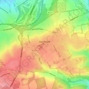
Name: Banstead topographic map, elevation, terrain.
Average elevation: 142 m
Minimum elevation: 88 m
Maximum elevation: 180 m
Surrey trails, hiking, mountain biking, running and outdoor activities
Other topographic maps
Click on a map to view its topography, its elevation and its terrain.
Redhill
United Kingdom > England > Surrey > Reigate and Banstead
To the north, the town joins with the village of Merstham, north of which there is a "wind gap" in the chalk hills of the North Downs, at an elevation of 120 metres (390 ft) above sea level, through which the A23 road heads in from London. Geologists have speculated that there may once have been a…
Average elevation: 107 m
Reigate
United Kingdom > England > Surrey > Reigate and Banstead
Reigate is in central Surrey, around 19 mi (30 km) south of central London and 9 mi (14 km) north of Gatwick Airport. The town is in the Vale of Holmesdale, below the North Downs escarpment. The average elevation in the centre is 80 m (260 ft) above ordnance datum (OD) and the area is drained by the Wallace…
Average elevation: 100 m
Gatton
United Kingdom > England > Surrey > Reigate and Banstead
Gatton's elevations range from 215m AOD, the highest elevation, along Fort Lane, a cul-de-sac off the intersection of Reigate Hill (M25 Junction 8) which leads to four homes over the boundary in Reigate, a radio transmitter station, and a water tower. On the A217 is the Bridge House Hotel, whose name refers to…
Average elevation: 134 m
Margery
United Kingdom > England > Surrey > Reigate and Banstead > Lower Kingswood
Average elevation: 155 m
Lower Earlswood Lake
United Kingdom > England > Surrey > Reigate and Banstead > Redhill
Average elevation: 75 m
Netherne-on-the-Hill
United Kingdom > England > Surrey > Reigate and Banstead
Average elevation: 153 m
Redhill Common
United Kingdom > England > Surrey > Reigate and Banstead > Redhill
Average elevation: 92 m
Nork Park
United Kingdom > England > Surrey > Reigate and Banstead > Banstead
Average elevation: 143 m
Buckland Corner
United Kingdom > England > Surrey > Reigate and Banstead > Reigate
Average elevation: 82 m
Norwood Hill
United Kingdom > England > Surrey > Reigate and Banstead > Norwood Hill
Average elevation: 71 m
Redhill
United Kingdom > England > Surrey > Reigate and Banstead
To the north, the town joins with the village of Merstham, north of which there is a "wind gap" in the chalk hills of the North Downs, at an elevation of 120 metres (390 feet) above sea level, through which the A23 road heads in from London. Geologists have speculated that there may once have been a…
Average elevation: 107 m
Reigate
United Kingdom > England > Surrey > Reigate and Banstead
Reigate is in central Surrey, around 19 mi (30 km) south of central London and 9 mi (14 km) north of Gatwick Airport. The town is in the Vale of Holmesdale, below the North Downs escarpment. The average elevation in the centre is 80 m (260 ft) above ordnance datum (OD) and the area is drained by the Wallace…
Average elevation: 100 m
Redhill
United Kingdom > England > Surrey > Reigate and Banstead
To the north, the town joins with the village of Merstham, north of which there is a "wind gap" in the chalk hills of the North Downs, at an elevation of 120 metres (390 feet) above sea level, through which the A23 road heads in from London. Geologists have speculated that there may once have been a…
Average elevation: 107 m
Margery
United Kingdom > England > Surrey > Reigate and Banstead > Lower Kingswood
Average elevation: 155 m
Redhill
United Kingdom > England > Surrey > Reigate and Banstead
To the north, the town joins with the village of Merstham, north of which there is a "wind gap" in the chalk hills of the North Downs, at an elevation of 120 metres (390 feet) above sea level, through which the A23 road heads in from London. Geologists have speculated that there may once have been a…
Average elevation: 107 m