
Make a donation
Gear up for your next adventure:
As an Amazon Associate, this site earns from qualifying purchases at no extra cost to you.
Redhill topographic map
Click on the map to display elevation.
Make a donation
Gear up for your next adventure:
As an Amazon Associate, this site earns from qualifying purchases at no extra cost to you.
Redhill
To the north, the town joins with the village of Merstham, north of which there is a "wind gap" in the chalk hills of the North Downs, at an elevation of 120 metres (390 ft) above sea level, through which the A23 road heads in from London. Geologists have speculated that there may once have been a consequent-flowing river, flowing northwards from the centre of the Weald-Artois Anticline and towards the River Thames, which originally cut both the Redhill Gap in the Greensand Ridge and the Merstham Gap in the chalk hills of the North Downs, before its waters were caught by subsequent streams of the River Mole (which itself cuts gaps northwards through the ridge at Betchworth, and through the Downs at Dorking, on its way to the Thames). Today the whole Redhill area is part of the catchment area of the River Mole, and hence the Thames.
Make a donation
Gear up for your next adventure:
As an Amazon Associate, this site earns from qualifying purchases at no extra cost to you.
About this map
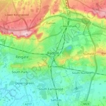
Name: Redhill topographic map, elevation, terrain.
Average elevation: 107 m
Minimum elevation: 47 m
Maximum elevation: 236 m
Surrey trails, hiking, mountain biking, running and outdoor activities
Make a donation
Gear up for your next adventure:
As an Amazon Associate, this site earns from qualifying purchases at no extra cost to you.
Other topographic maps
Click on a map to view its topography, its elevation and its terrain.
Lower Earlswood Lake
United Kingdom > England > Surrey > Reigate and Banstead > Redhill
Average elevation: 75 m
Redhill Common
United Kingdom > England > Surrey > Reigate and Banstead > Redhill
Average elevation: 92 m
Banstead Wood
United Kingdom > England > Surrey > Reigate and Banstead > Chipstead
Average elevation: 145 m
Make a donation
Gear up for your next adventure:
As an Amazon Associate, this site earns from qualifying purchases at no extra cost to you.
Reigate Park
United Kingdom > England > Surrey > Reigate and Banstead > Reigate
Average elevation: 80 m
Horley
United Kingdom > England > Surrey > Reigate and Banstead
Horley is at an altitude of around 54 m (177 ft) above mean sea level.
Average elevation: 58 m