Geolocate

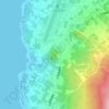
Anijima topographic map

Click on the map to display elevation.

About this map

Name: Anijima topographic map, elevation, terrain.

Location: Anijima, Ogasawara Subprefecture, Tokyo, Japan (27.10842 142.18676 27.14420 142.23613)

Average elevation: 34 m

Minimum elevation: -14 m

Maximum elevation: 242 m

Other topographic maps

Click on a map to view its topography, its elevation and its terrain.
Mt. Hakone Yama

Japan > Tokyo

Average elevation: 32 m

Mount Atago

Japan > Tokyo

Average elevation: 60 m

Odaiba

Japan > Tokyo

Average elevation: 26 m

Gear up for your next adventure:

🍱Food Containers - Reusable containers for outdoor meals
🍲Portable Camping Stoves - Fast-boiling stoves for hot meals on remote topographic survey trips
☕Insulated Travel Mugs - Keep drinks hot while surveying the landscape from a summit
🛌Sleeping Mats - Insulated mats for comfortable outdoor sleeping
🛌Insulated Sleeping Mats - Crucial thermal protection when sleeping on cold, uneven ground

As an Amazon Associate, this site earns from qualifying purchases at no extra cost to you.