Geolocate

Zweeloo topographic map

Click on the map to display elevation.

About this map

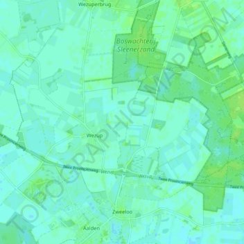
Name: Zweeloo topographic map, elevation, terrain.

Location: Zweeloo, Coevorden, Drenthe, Nederland (52.78711 6.70905 52.84160 6.77114)

Average elevation: 19 m

Minimum elevation: 15 m

Maximum elevation: 25 m

Other topographic maps

Click on a map to view its topography, its elevation and its terrain.

De Bente

Nederland > Drenthe > Coevorden > Dalen

Average elevation: 12 m

Achterste-Erm

Nederland > Drenthe > Coevorden > Erm

Average elevation: 15 m

Steenwijksmoer

Nederland > Drenthe > Coevorden

Average elevation: 11 m

Veenhuizen

Nederland > Drenthe > Coevorden > Dalen

Average elevation: 12 m

Den Hool

Nederland > Drenthe > Coevorden

Average elevation: 13 m

Vossebelt

Nederland > Drenthe > Coevorden > Dalen

Average elevation: 11 m

Vlieghuis

Nederland > Drenthe > Coevorden

Average elevation: 12 m

Gear up for your next adventure:

💧Hydration Reservoirs - Convenient water bladders for hands-free drinking on the move
🥾Women's Waterproof Hiking Boots - High-performance trekking boots designed for all-weather comfort
👟Heavy Duty Boot Laces - Always carry a spare for your hiking footwear
🛰️Outdoor GPS Navigation - Navigation devices for remote and off-grid areas
🧥Breathable Waterproof Jackets - Essential rain protection for the unpredictable British climate

As an Amazon Associate, this site earns from qualifying purchases at no extra cost to you.