
Grub (AR) topographic map
Interactive map
Click on the map to display elevation.
About this map
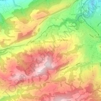
Name: Grub (AR) topographic map, elevation, terrain.
Location: Grub (AR), Vorderland, Appenzell Ausserrhoden, 9035, Schweiz (47.42839 9.46813 47.45184 9.52521)
Average elevation: 891 m
Minimum elevation: 608 m
Maximum elevation: 1,111 m
Other topographic maps
Click on a map to view its topography, its elevation and its terrain.
Reute (AR)
Schweiz > Appenzell Ausserrhoden > Vorderland
Reute (AR), Vorderland, Appenzell Ausserrhoden, 9414, Schweiz
Average elevation: 733 m
Heiden
Schweiz > Appenzell Ausserrhoden > Vorderland > Heiden > Heiden
Heiden, Vorderland, Appenzell Ausserrhoden, 9410, Schweiz
Average elevation: 835 m