
Make a donation
Gear up for your next adventure:
As an Amazon Associate, this site earns from qualifying purchases at no extra cost to you.
Oberrasen topographic map
Click on the map to display elevation.
Make a donation
Gear up for your next adventure:
As an Amazon Associate, this site earns from qualifying purchases at no extra cost to you.
About this map
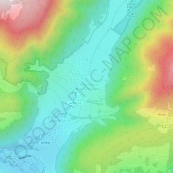
Name: Oberrasen topographic map, elevation, terrain.
Average elevation: 1,331 m
Minimum elevation: 989 m
Maximum elevation: 2,033 m
Make a donation
Gear up for your next adventure:
As an Amazon Associate, this site earns from qualifying purchases at no extra cost to you.
Other topographic maps
Click on a map to view its topography, its elevation and its terrain.
Antholzer Tal
Italien > Trentino-Südtirol > Bozen > Rasen-Antholz
Das Antholzer Tal oder einfach Antholz (italienisch Valle di Anterselva) ist ein Seitental des Pustertales in Südtirol (Italien). Es zweigt bei Olang in nördliche Richtung vom Pustertal ab und setzt sich ab Antholz Mittertal in nordöstliche Richtung fort. Das gesamte Tal gehört zum Gemeindegebiet von…
Average elevation: 1,867 m