
Make a donation
Gear up for your next adventure:
As an Amazon Associate, this site earns from qualifying purchases at no extra cost to you.
Antholzer Tal topographic map
Click on the map to display elevation.
Make a donation
Gear up for your next adventure:
As an Amazon Associate, this site earns from qualifying purchases at no extra cost to you.
Antholzer Tal
Das Antholzer Tal oder einfach Antholz (italienisch Valle di Anterselva) ist ein Seitental des Pustertales in Südtirol (Italien). Es zweigt bei Olang in nördliche Richtung vom Pustertal ab und setzt sich ab Antholz Mittertal in nordöstliche Richtung fort. Das gesamte Tal gehört zum Gemeindegebiet von Rasen-Antholz. Das Tal erstreckt sich über 21 Kilometer bis zum Staller Sattel (2052 m), dem Übergang zum Osttiroler Defereggental. Im Westen und Norden wird das Tal von den Bergen der Rieserfernergruppe dominiert, im Osten erheben sich die Villgratner Berge. Durchflossen wird das Tal vom Antholzer Bach. Auf einer Höhe von 1642 m befindet sich im Talgrund der 44 Hektar große Antholzer See, der wie ein Großteil der orographisch rechten Talflanken im Naturpark Rieserferner-Ahrn unter Schutz gestellt ist.
Make a donation
Gear up for your next adventure:
As an Amazon Associate, this site earns from qualifying purchases at no extra cost to you.
About this map
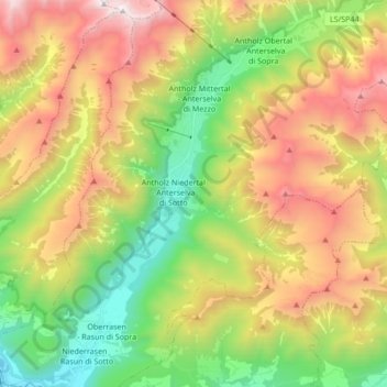
Name: Antholzer Tal topographic map, elevation, terrain.
Average elevation: 1,867 m
Minimum elevation: 970 m
Maximum elevation: 3,065 m
Make a donation
Gear up for your next adventure:
As an Amazon Associate, this site earns from qualifying purchases at no extra cost to you.
Other topographic maps
Click on a map to view its topography, its elevation and its terrain.
Turismuszone Antholz Obertal
Italien > Trentino-Südtirol > Bozen > Rasen-Antholz > Antholz Obertal
Average elevation: 1,943 m