Geolocate

Wokingham topographic map

Click on the map to display elevation.

About this map

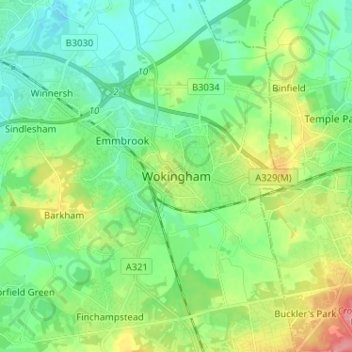
Name: Wokingham topographic map, elevation, terrain.

Location: Wokingham, South East, England, RG40 1TG, United Kingdom (51.37203 -0.87240 51.45203 -0.79240)

Average elevation: 61 m

Minimum elevation: 33 m

Maximum elevation: 126 m

England trails, hiking, mountain biking, running and outdoor activities

Gear up for your next adventure:

📻Hand-Crank Emergency Radios - Stay updated on weather warnings in remote areas
🛰️Satellite Messengers - Emergency communication devices for areas without mobile signal
👟Men's Trail Running Shoes - Lightweight grip for fast movement over topographic contours
🔭Compact Hiking Binoculars - Lightweight optics for scouting terrain and spotting wildlife
🔥Reusable Hand Warmers - Maintain dexterity in your fingers for precise map handling

As an Amazon Associate, this site earns from qualifying purchases at no extra cost to you.