Geolocate

Dunorlan topographic map

Click on the map to display elevation.

About this map

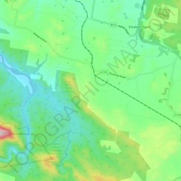
Name: Dunorlan topographic map, elevation, terrain.

Location: Dunorlan, Meander Valley, Tasmania, 7304, Australia (-41.52100 146.49102 -41.46863 146.60207)

Average elevation: 251 m

Minimum elevation: 96 m

Maximum elevation: 676 m

Other topographic maps

Click on a map to view its topography, its elevation and its terrain.

Frog Hill

Australia > Tasmania

Average elevation: 875 m

Tasman Peninsula

Australia > Tasmania > Tasman > Fortescue

Average elevation: 167 m

Ulverstone

Australia > Tasmania > Ulverstone

Average elevation: 37 m

Mount Kate

Australia > Tasmania

Average elevation: 995 m

Mount Jukes

Australia > Tasmania

Average elevation: 773 m

Bullock Hill

Australia > Tasmania > Grove

Average elevation: 147 m

Highland Waters

Australia > Tasmania > London Lakes

Average elevation: 759 m

Stillwater Hill

Australia > Tasmania

Average elevation: 353 m

Legges Tor

Australia > Tasmania

Average elevation: 1,457 m

Rowlands Hill

Australia > Tasmania

Average elevation: 388 m

Recherche Bay

Australia > Tasmania

Average elevation: 10 m

Bastyan Dam

Australia > Tasmania > Tullah

Average elevation: 233 m

Gear up for your next adventure:

🌄Outdoor Binoculars - Compact binoculars for landscape observation
🧰Survival Kits - Emergency tools for remote environments
🔋Solar Chargers - Eco-friendly charging solutions for outdoor use
🕶️Glacier Goggles - Maximum protection for high-altitude snow topography
🎿Telescopic Trekking Poles - Reduces knee strain on steep topographic descents

As an Amazon Associate, this site earns from qualifying purchases at no extra cost to you.