
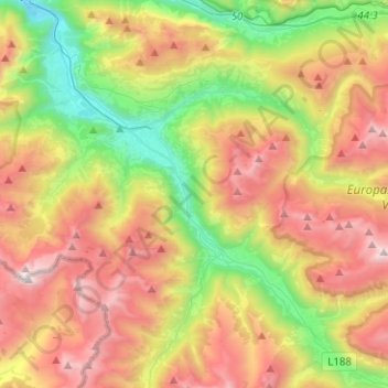
Montafon topographic map
Interactive map
Click on the map to display elevation.
About this map
Name: Montafon topographic map, elevation, terrain.
Average elevation: 1,566 m
Minimum elevation: 577 m
Maximum elevation: 2,788 m
Das Montafon (anhören) ist ein 39 Kilometer langes Tal in Vorarlberg (Österreich), das von der Bielerhöhe bis Bludenz reicht und von der Ill durchflossen wird. Das Tal wird im Norden von der Verwallgruppe und im Süden vom Rätikon und der Silvretta begrenzt. Die höchste Erhebung in der Umgebung ist der 3312 m hohe Piz Buin in der Silvretta-Gruppe.
Other topographic maps
Click on a map to view its topography, its elevation and its terrain.
Gargellen
Österreich > Vorarlberg > Bezirk Bludenz > Gemeinde Sankt Gallenkirch
Gargellen, Gemeinde Sankt Gallenkirch, Bezirk Bludenz, Vorarlberg, 6791, Österreich
Average elevation: 1,799 m
Gortipohl
Österreich > Vorarlberg > Bezirk Bludenz > Gemeinde Sankt Gallenkirch > Gortipohl
Gortipohl, Gemeinde Sankt Gallenkirch, Bezirk Bludenz, Vorarlberg, 6791, Österreich
Average elevation: 1,324 m