
Leicestershire topographic map
Interactive map
Click on the map to display elevation.
About this map
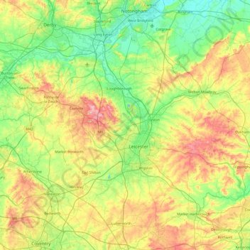
Name: Leicestershire topographic map, elevation, terrain.
Location: Leicestershire, England, United Kingdom (52.39217 -1.59755 52.97766 -0.66411)
Average elevation: 98 m
Minimum elevation: 16 m
Maximum elevation: 269 m
A large part of the north-west of the county, around Coalville, forms part of the new National Forest area extending into Derbyshire and Staffordshire. The highest point of the county is Bardon Hill at 278 m (912 ft), which is also a Marilyn; with other hilly/upland areas of c. 150–200 metres (490–660 ft) and above in nearby Charnwood Forest and also to the east of the county around Launde Abbey. The lowest point, at an altitude of about 20 metres (66 ft), is located at the county's northernmost tip close to Bottesford where the River Devon flowing through the Vale of Belvoir leaves Leicestershire and enters Nottinghamshire. This results in an altitude differential (AΔ|vertical) of around 257.5 metres (845 ft) and a mean altitude of 148.75 metres (488.0 ft).
Other topographic maps
Click on a map to view its topography, its elevation and its terrain.
Leicester
United Kingdom > England > Leicestershire
Leicester, Leicestershire, England, LE1 5YA, United Kingdom
Average elevation: 109 m
Loughborough
United Kingdom > England > Leicestershire > Charnwood
Loughborough, Charnwood, Leicestershire, England, LE11 5BJ, United Kingdom
Average elevation: 61 m
Market Harborough
United Kingdom > England > Leicestershire > Harborough
Market Harborough, Harborough, Leicestershire, England, LE16 7PA, United Kingdom
Average elevation: 106 m
Melton Mowbray
United Kingdom > England > Leicestershire > Melton
Melton Mowbray, Melton, Leicestershire, England, LE13 0PU, United Kingdom
Average elevation: 103 m
Normanton Le Heath
United Kingdom > England > Leicestershire > North West Leicestershire
Normanton Le Heath, North West Leicestershire, Leicestershire, England, United Kingdom
Average elevation: 123 m
Bagworth
United Kingdom > England > Leicestershire > Hinckley and Bosworth
Bagworth, Hinckley and Bosworth, Leicestershire, England, LE67 1BX, United Kingdom
Average elevation: 151 m
Claybrooke Magna
United Kingdom > England > Leicestershire > Harborough
Claybrooke Magna, Harborough, Leicestershire, England, LE17 5DU, United Kingdom
Average elevation: 110 m
Shawell
United Kingdom > England > Leicestershire
Shawell, Leicestershire, England, United Kingdom
Average elevation: 127 m
Scraptoft
United Kingdom > England > Leicestershire > Harborough
Scraptoft, Harborough, Leicestershire, England, LE7 9TE, United Kingdom
Average elevation: 103 m
Thurmaston
United Kingdom > England > Leicestershire > Charnwood
Thurmaston, Charnwood, Leicestershire, England, United Kingdom
Average elevation: 62 m
Drayton
United Kingdom > England > Leicestershire > Harborough
Drayton, Harborough, Leicestershire, England, LE16 8RG, United Kingdom
Average elevation: 82 m
New Lubbesthorpe
United Kingdom > England > Leicestershire > Leicester Forest East
New Lubbesthorpe, Lubbesthorpe, Leicester Forest East, Blaby, Leicestershire, England, LE19 4DA, United Kingdom
Average elevation: 95 m
Croft
United Kingdom > England > Leicestershire
Croft, Blaby, Leicestershire, England, LE9 3HF, United Kingdom
Average elevation: 77 m
Brooksby
United Kingdom > England > Leicestershire > Melton > Rotherby
Brooksby, Hoby with Rotherby, Rotherby, Melton, Leicestershire, England, LE14 2LE, United Kingdom
Average elevation: 76 m
Osgathorpe
United Kingdom > England > Leicestershire > North West Leicestershire
Osgathorpe, North West Leicestershire, Leicestershire, England, United Kingdom
Average elevation: 96 m
Thornton
United Kingdom > England > Leicestershire > Hinckley and Bosworth
Thornton, Hinckley and Bosworth, Leicestershire, England, LE67 1AF, United Kingdom
Average elevation: 146 m
Hinckley
United Kingdom > England > Leicestershire > Hinckley and Bosworth
Hinckley, Hinckley and Bosworth, Leicestershire, England, LE10 1NR, United Kingdom
Average elevation: 105 m
Cropston
United Kingdom > England > Leicestershire > Charnwood
Cropston, Charnwood, Leicestershire, England, LE7 7GE, United Kingdom
Average elevation: 83 m
Narborough
United Kingdom > England > Leicestershire
Narborough, Blaby, Leicestershire, England, United Kingdom
Average elevation: 78 m
Ulverscroft
United Kingdom > England > Leicestershire > Charnwood
Ulverscroft, Charnwood, Leicestershire, England, United Kingdom
Average elevation: 187 m
Charnwood Water
United Kingdom > England > Leicestershire > Charnwood > Woodthorpe
Charnwood Water, Woodthorpe, Charnwood, Leicestershire, England, United Kingdom
Average elevation: 47 m
Ab Kettleby
United Kingdom > England > Leicestershire > Melton
Ab Kettleby, Melton, Leicestershire, England, United Kingdom
Average elevation: 126 m
Pickwell
United Kingdom > England > Leicestershire > Melton
Pickwell, Melton, Leicestershire, England, LE14 2PL, United Kingdom
Average elevation: 168 m
Willoughby Waterleys
United Kingdom > England > Leicestershire > Harborough
Willoughby Waterleys, Harborough, Leicestershire, England, LE8 6UD, United Kingdom
Average elevation: 106 m
Newtown Linford
United Kingdom > England > Leicestershire > Charnwood
Newtown Linford, Charnwood, Leicestershire, England, United Kingdom
Average elevation: 115 m
Gilmorton
United Kingdom > England > Leicestershire > Harborough
Gilmorton, Harborough, Leicestershire, England, United Kingdom
Average elevation: 136 m
Lubbesthorpe
United Kingdom > England > Leicestershire > Braunstone Town
Lubbesthorpe, Braunstone Town, Blaby, Leicestershire, England, United Kingdom
Average elevation: 83 m
Kegworth
United Kingdom > England > Leicestershire > North West Leicestershire
Kegworth, North West Leicestershire, Leicestershire, England, DE74 2EE, United Kingdom
Average elevation: 47 m
Lount
United Kingdom > England > Leicestershire > North West Leicestershire
Lount, North West Leicestershire, Leicestershire, England, LE65 1SN, United Kingdom
Average elevation: 118 m
King's Norton
United Kingdom > England > Leicestershire > Harborough
King's Norton, Harborough, Leicestershire, England, LE7 9BF, United Kingdom
Average elevation: 147 m
Market Bosworth Country Park
United Kingdom > England > Leicestershire > Hinckley and Bosworth > Market Bosworth
Market Bosworth Country Park, Market Bosworth, Hinckley and Bosworth, Leicestershire, England, United Kingdom
Average elevation: 119 m
Illston on the Hill
United Kingdom > England > Leicestershire > Harborough
Illston on the Hill, Harborough, Leicestershire, England, LE7 9ET, United Kingdom
Average elevation: 157 m
Ashby-de-la-Zouch
United Kingdom > England > Leicestershire > North West Leicestershire
Ashby-de-la-Zouch, North West Leicestershire, Leicestershire, England, United Kingdom
Average elevation: 132 m
Shangton
United Kingdom > England > Leicestershire > Harborough
Shangton, Harborough, Leicestershire, England, LE8 0PG, United Kingdom
Average elevation: 127 m
Kelham Bridge Nature Reserve
United Kingdom > England > Leicestershire > North West Leicestershire > Ravenstone
Kelham Bridge Nature Reserve, Melbourne Road, Hugglescote and Donington le Heath, Ravenstone, North West Leicestershire, Leicestershire, England, LE67 2AN, United Kingdom
Average elevation: 139 m
Goadby
United Kingdom > England > Leicestershire > Harborough
Goadby, Harborough, Leicestershire, England, LE7 9EX, United Kingdom
Average elevation: 148 m
South Croxton
United Kingdom > England > Leicestershire > Charnwood
South Croxton, Charnwood, Leicestershire, England, LE7 3RL, United Kingdom
Average elevation: 110 m
Tugby
United Kingdom > England > Leicestershire > Harborough
Tugby, Harborough, Leicestershire, England, LE7 9WF, United Kingdom
Average elevation: 158 m
Rolleston
United Kingdom > England > Leicestershire > Harborough
Rolleston, Harborough, Leicestershire, England, LE7 9EN, United Kingdom
Average elevation: 166 m
Burton Overy
United Kingdom > England > Leicestershire > Harborough
Burton Overy, Harborough, Leicestershire, England, LE8 9DD, United Kingdom
Average elevation: 130 m
Belvoir Castle
United Kingdom > England > Leicestershire > Melton > Belvoir
Belvoir Castle, Woolsthorpe Road, Belvoir, Melton, Leicestershire, England, NG32 1PH, United Kingdom
Average elevation: 82 m
Lea Wood
United Kingdom > England > Leicestershire > Charnwood > Newtown Linford
Lea Wood, Ulverscroft, Newtown Linford, Charnwood, Leicestershire, England, United Kingdom
Average elevation: 170 m
Conservation Area
United Kingdom > England > Leicestershire > Charnwood
Conservation Area, Pig Path, Beacon Cottage Farm, Woodhouse, Charnwood, Leicestershire, England, LE12 8TE, United Kingdom
Average elevation: 168 m
Willesley Woods
United Kingdom > England > Leicestershire > North West Leicestershire > Ashby-de-la-Zouch > Willesley
Willesley Woods, Willesley Wood Side, Ashby-de-la-Zouch, Willesley, North West Leicestershire, Leicestershire, England, LE65 2UP, United Kingdom
Average elevation: 108 m
Moat Hill Spinney
United Kingdom > England > Leicestershire > Charnwood > Cotes
Moat Hill Spinney, Cotes, Charnwood, Leicestershire, England, United Kingdom
Average elevation: 50 m
Thornton Reservoir
United Kingdom > England > Leicestershire > Hinckley and Bosworth > Thornton
Thornton Reservoir, Bagworth & Thornton, Thornton, Hinckley and Bosworth, Leicestershire, England, United Kingdom
Average elevation: 139 m
Coalville
United Kingdom > England > Leicestershire > North West Leicestershire
Coalville, North West Leicestershire, Leicestershire, England, LE67 3DW, United Kingdom
Average elevation: 149 m
Earl Shilton
United Kingdom > England > Leicestershire
Earl Shilton, Leicestershire, England, United Kingdom
Average elevation: 101 m
Kilby Bridge
United Kingdom > England > Leicestershire > Oadby and Wigston > Wigston
Kilby Bridge, Wigston, Oadby and Wigston, Leicestershire, England, LE18 3TF, United Kingdom
Average elevation: 89 m
Merry Lees
United Kingdom > England > Leicestershire > Hinckley and Bosworth > Botcheston
Merry Lees, Bagworth & Thornton, Botcheston, Hinckley and Bosworth, Leicestershire, England, LE67 1AP, United Kingdom
Average elevation: 126 m