
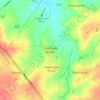
Claybrooke Magna topographic map
Interactive map
Click on the map to display elevation.
About this map
Name: Claybrooke Magna topographic map, elevation, terrain.
Average elevation: 110 m
Minimum elevation: 83 m
Maximum elevation: 138 m
Leicestershire trails, hiking, mountain biking, running and outdoor activities
Other topographic maps
Click on a map to view its topography, its elevation and its terrain.
Claybrooke Magna
United Kingdom > England > Leicestershire > Harborough > Claybrooke Magna
Average elevation: 102 m
Adrian's Spinney
United Kingdom > England > Leicestershire > Harborough > Stoughton
Average elevation: 113 m
Little Stretton
United Kingdom > England > Leicestershire > Harborough > Little Stretton
Average elevation: 132 m
Saddington
United Kingdom > England > Leicestershire > Harborough > Saddington
Average elevation: 127 m
Kimcote and Walton
United Kingdom > England > Leicestershire > Harborough > Kimcote and Walton
Average elevation: 144 m
Broughton Astley
United Kingdom > England > Leicestershire > Harborough > Broughton Astley
Average elevation: 87 m
Husbands Bosworth
United Kingdom > England > Leicestershire > Harborough > Husbands Bosworth
Average elevation: 142 m