Geolocate

Illston on the Hill topographic map

Click on the map to display elevation.

About this map

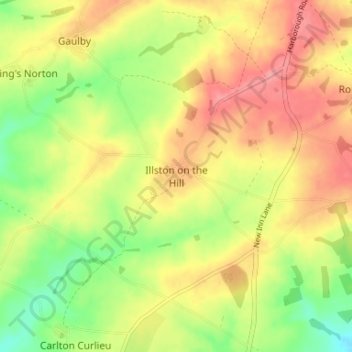
Name: Illston on the Hill topographic map, elevation, terrain.

Location: Illston on the Hill, Harborough, Leicestershire, England, LE7 9ET, United Kingdom (52.56691 -0.97658 52.60691 -0.93658)

Average elevation: 157 m

Minimum elevation: 106 m

Maximum elevation: 203 m

Leicestershire trails, hiking, mountain biking, running and outdoor activities

Other topographic maps

Click on a map to view its topography, its elevation and its terrain.

Hallaton

United Kingdom > England > Leicestershire > Harborough > Hallaton

Average elevation: 125 m

Catthorpe

United Kingdom > England > Leicestershire > Harborough

Average elevation: 116 m

Billesdon

United Kingdom > England > Leicestershire > Harborough

Average elevation: 179 m

Marefield

United Kingdom > England > Leicestershire > Harborough

Average elevation: 141 m

Fleckney

United Kingdom > England > Leicestershire > Harborough

Average elevation: 121 m

Shawell

United Kingdom > England > Leicestershire > Harborough

Average elevation: 127 m

Gilmorton

United Kingdom > England > Leicestershire > Harborough

Average elevation: 136 m

Gumley

United Kingdom > England > Leicestershire > Harborough

Average elevation: 130 m

Foxton

United Kingdom > England > Leicestershire > Harborough

Average elevation: 102 m

Glooston

United Kingdom > England > Leicestershire > Harborough

Average elevation: 120 m

Shearsby

United Kingdom > England > Leicestershire > Harborough > Shearsby

Average elevation: 131 m

Walcote

United Kingdom > England > Leicestershire > Harborough

Average elevation: 132 m

Allexton

United Kingdom > England > Leicestershire > Harborough

Average elevation: 121 m

Launde

United Kingdom > England > Leicestershire > Harborough

Average elevation: 165 m

Gaulby

United Kingdom > England > Leicestershire > Harborough > Gaulby

Average elevation: 155 m

Goadby

United Kingdom > England > Leicestershire > Harborough

Average elevation: 147 m

Blaston

United Kingdom > England > Leicestershire > Harborough > Blaston

Average elevation: 111 m

Keyham

United Kingdom > England > Leicestershire > Harborough > Keyham

Average elevation: 122 m

Cotesbach

United Kingdom > England > Leicestershire > Harborough

Average elevation: 121 m

Medbourne

United Kingdom > England > Leicestershire > Harborough

Average elevation: 91 m

Lubenham

United Kingdom > England > Leicestershire > Harborough

Average elevation: 110 m

Swinford

United Kingdom > England > Leicestershire > Harborough > Swinford

Average elevation: 124 m

Walcote

United Kingdom > England > Leicestershire > Harborough

Average elevation: 132 m

Gear up for your next adventure:

🧢Waterproof Hiking Hats - Keep the rain off your face while studying topographic maps
🍱Food Containers - Reusable containers for outdoor meals
🔦Keychain LED Torches - Emergency backup light for finding gear in your pack
🥤Hydration Bladders - Hands-free hydration systems for backpacks
🔋Rechargeable Batteries - Eco-friendly power for headlamps and older GPS units

As an Amazon Associate, this site earns from qualifying purchases at no extra cost to you.