
Bernard topographic map
Interactive map
Click on the map to display elevation.
About this map
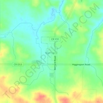
Name: Bernard topographic map, elevation, terrain.
Location: Bernard, Dubuque County, Iowa, États-Unis d'Amérique (42.30893 -90.83516 42.31663 -90.82931)
Average elevation: 289 m
Minimum elevation: 270 m
Maximum elevation: 318 m
Other topographic maps
Click on a map to view its topography, its elevation and its terrain.
Graf
États-Unis d'Amérique > Iowa > Dubuque County
Graf, Dubuque County, Iowa, États-Unis d'Amérique
Average elevation: 260 m