
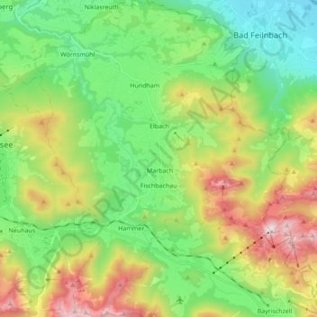
Fischbachau topographic map
Interactive map
Click on the map to display elevation.
About this map
Name: Fischbachau topographic map, elevation, terrain.
Location: Fischbachau, Landkreis Miesbach, Bavaria, 83730, Germany (47.67155 11.88444 47.78732 12.02302)
Average elevation: 928 m
Minimum elevation: 471 m
Maximum elevation: 1,803 m
Other topographic maps
Click on a map to view its topography, its elevation and its terrain.
Hubertus
Germany > Bavaria > Landkreis Miesbach > Kreuth
Hubertus, Kreuth, Landkreis Miesbach, Bavaria, Germany
Average elevation: 1,068 m
Schliersee
Germany > Bavaria > Landkreis Miesbach
Schliersee, Landkreis Miesbach, Bavaria, 83727, Germany
Average elevation: 1,079 m
Bad Wiessee
Germany > Bavaria > Landkreis Miesbach
Bad Wiessee, Landkreis Miesbach, Bavaria, 83707, Germany
Average elevation: 942 m