
Munster topographic map
Interactive map
Click on the map to display elevation.
About this map
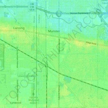
Name: Munster topographic map, elevation, terrain.
Location: Munster, Lake County, Indiana, 46321, United States (41.52261 -87.52550 41.58139 -87.48062)
Average elevation: 187 m
Minimum elevation: 180 m
Maximum elevation: 194 m
Other topographic maps
Click on a map to view its topography, its elevation and its terrain.
Winfield Township
United States > Indiana > Lake County
Winfield Township, Lake County, Indiana, United States
Average elevation: 220 m
Lake Seven
United States > Indiana > Lake County > Crown Point
Lake Seven, Crown Point, Lake County, Indiana, United States
Average elevation: 220 m
Lake Station
United States > Indiana > Lake County
Lake Station, Lake County, Indiana, 46405, United States
Average elevation: 189 m
Glen Park
United States > Indiana > Lake County > Gary
Glen Park, Gary, Lake County, Indiana, 46409, United States
Average elevation: 193 m
Miller
United States > Indiana > Lake County > Gary > Miller
Miller, Gary, Lake County, Indiana, 46403, United States
Average elevation: 186 m
Hammond
United States > Indiana > Lake County
Hammond, Lake County, Indiana, United States
Average elevation: 180 m
Griffith
United States > Indiana > Lake County > Griffith
Griffith, Lake County, Indiana, 46319, United States
Average elevation: 190 m
Crown Point
United States > Indiana > Lake County > Crown Point
Crown Point, Lake County, Indiana, 46307, United States
Average elevation: 220 m
Gary
United States > Indiana > Lake County > Gary
Gary, Lake County, Indiana, United States
Average elevation: 185 m