
Make a donation
Gear up for your next adventure:
As an Amazon Associate, this site earns from qualifying purchases at no extra cost to you.
Gerbrunn topographic map
Click on the map to display elevation.
Make a donation
Gear up for your next adventure:
As an Amazon Associate, this site earns from qualifying purchases at no extra cost to you.
About this map
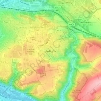
Name: Gerbrunn topographic map, elevation, terrain.
Location: Gerbrunn, Landkreis Würzburg, Bayern, 97218, Deutschland (49.77139 9.97516 49.79019 10.03296)
Average elevation: 254 m
Minimum elevation: 170 m
Maximum elevation: 338 m
Make a donation
Gear up for your next adventure:
As an Amazon Associate, this site earns from qualifying purchases at no extra cost to you.
Other topographic maps
Click on a map to view its topography, its elevation and its terrain.
Goßmannsdorf
Deutschland > Bayern > Landkreis Würzburg > Ochsenfurt
Vom 14. bis ins 19. Jahrhundert hatte der Ort eine geschlossene Dorfbefestigung, die aus einer Ringmauer mit drei großen und sieben kleinen Türmen bestand. Sie ist nur noch teilweise in ihrer alten Höhe erhalten.
Average elevation: 246 m
Make a donation
Gear up for your next adventure:
As an Amazon Associate, this site earns from qualifying purchases at no extra cost to you.
Make a donation
Gear up for your next adventure:
As an Amazon Associate, this site earns from qualifying purchases at no extra cost to you.
Make a donation
Gear up for your next adventure:
As an Amazon Associate, this site earns from qualifying purchases at no extra cost to you.
Maidbronn
Deutschland > Bayern > Landkreis Würzburg
Die Bundesautobahn 7 begrenzt im Wesentlichen die Gemarkungen an der östlichen Grenze. Nach Süden hin läuft die Gemarkungsgrenze auf dem Höhenzug entlang, über die Höhe 304 zwischen Estenfeld und Maidbronn, vorbei am Versbacher Breitholz (Eichig), bis zum Dreimarker Rimpar-Versbach-Maidbronn. Von da an…
Average elevation: 275 m
Make a donation
Gear up for your next adventure:
As an Amazon Associate, this site earns from qualifying purchases at no extra cost to you.
Hausen bei Würzburg
Deutschland > Bayern > Landkreis Würzburg > Hausen b. Würzburg
Average elevation: 297 m
Make a donation
Gear up for your next adventure:
As an Amazon Associate, this site earns from qualifying purchases at no extra cost to you.
Make a donation
Gear up for your next adventure:
As an Amazon Associate, this site earns from qualifying purchases at no extra cost to you.