
Make a donation
Gear up for your next adventure:
As an Amazon Associate, this site earns from qualifying purchases at no extra cost to you.
Taszów topographic map
Click on the map to display elevation.
Make a donation
Gear up for your next adventure:
As an Amazon Associate, this site earns from qualifying purchases at no extra cost to you.
About this map
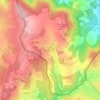
Name: Taszów topographic map, elevation, terrain.
Average elevation: 619 m
Minimum elevation: 488 m
Maximum elevation: 696 m
Make a donation
Gear up for your next adventure:
As an Amazon Associate, this site earns from qualifying purchases at no extra cost to you.
Other topographic maps
Click on a map to view its topography, its elevation and its terrain.
Kowadło/Kovadlina
Poland > Lower Silesian Voivodeship > Kłodzko County > Bielice
Average elevation: 793 m
Bystrzyca Kłodzka
Poland > Lower Silesian Voivodeship > Kłodzko County > Bystrzyca Kłodzka > Bystrzyca Kłodzka
Average elevation: 404 m
Make a donation
Gear up for your next adventure:
As an Amazon Associate, this site earns from qualifying purchases at no extra cost to you.