
Kındıra topographic map
Interactive map
Click on the map to display elevation.
About this map
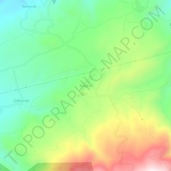
Name: Kındıra topographic map, elevation, terrain.
Location: Kındıra, Bolu Merkez, Bolu, Black Sea Region, Turkey (40.69964 31.73658 40.73964 31.77658)
Average elevation: 1,004 m
Minimum elevation: 749 m
Maximum elevation: 1,433 m
Other topographic maps
Click on a map to view its topography, its elevation and its terrain.
Aladağ Göleti
Aladağ Göleti, Bolu Merkez, Bolu, Black Sea Region, Turkey
Average elevation: 1,376 m
Hayreddin-i Tokadı Türbesi
Turkey > Bolu Merkez > Elmalık
Hayreddin-i Tokadı Türbesi, Elmalık, Bolu Merkez, Bolu, Black Sea Region, Turkey
Average elevation: 924 m