
Make a donation
Gear up for your next adventure:
As an Amazon Associate, this site earns from qualifying purchases at no extra cost to you.
Sequoia topographic map
Click on the map to display elevation.
Make a donation
Gear up for your next adventure:
As an Amazon Associate, this site earns from qualifying purchases at no extra cost to you.
About this map
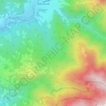
Name: Sequoia topographic map, elevation, terrain.
Average elevation: 607 m
Minimum elevation: 357 m
Maximum elevation: 1,027 m
Make a donation
Gear up for your next adventure:
As an Amazon Associate, this site earns from qualifying purchases at no extra cost to you.
Other topographic maps
Click on a map to view its topography, its elevation and its terrain.
Make a donation
Gear up for your next adventure:
As an Amazon Associate, this site earns from qualifying purchases at no extra cost to you.
Kyiv
Originally on the west bank, today Kyiv is on both sides of the Dnieper, which flows southwards through the city towards the Black Sea. The older and higher western part of the city sits on numerous wooded hills (Kyiv Hills), with ravines and small rivers. Kyiv's geographical relief contributed to its…
Average elevation: 133 m
Make a donation
Gear up for your next adventure:
As an Amazon Associate, this site earns from qualifying purchases at no extra cost to you.
Lviv
Lviv is on the edge of the Roztochia Upland, about 70 kilometres (43 miles) east of Polish border and 160 km (99 mi) north of the eastern Carpathian Mountains. The average altitude of Lviv is 296 metres (971 feet) above sea level. Its highest point is the Vysokyi Zamok (High Castle), 409 meters (1342 feet)…
Average elevation: 309 m
Make a donation
Gear up for your next adventure:
As an Amazon Associate, this site earns from qualifying purchases at no extra cost to you.
Bakhmut
Bakhmut, located in the Donetsk Oblast of eastern Ukraine, lies in a region characterized by relatively flat terrain, with its elevation around 328 feet (100 meters) above sea level. The city is situated along the Bakhmutka River, which contributes to the area's relatively mild topographic features. The…
Average elevation: 139 m
Make a donation
Gear up for your next adventure:
As an Amazon Associate, this site earns from qualifying purchases at no extra cost to you.
Make a donation
Gear up for your next adventure:
As an Amazon Associate, this site earns from qualifying purchases at no extra cost to you.
Kharkiv
Based on Kharkiv's topography, the city can be conditionally divided into four lower districts and four higher districts.
Average elevation: 146 m
Dnipro
Ukraine > Dnipropetrovsk Oblast
Under the Köppen–Geiger climate classification system, Dnipro has a humid continental climate (Dfa/Dfb). Snowfall is more common in the hills than at the city's lower elevations. The city has four distinct seasons: a cold, snowy winter; a hot summer; and two relatively wet transition periods. However,…
Average elevation: 90 m
Kharkiv
Based on Kharkiv's topography, the city can be conditionally divided into four lower districts and four higher districts.
Average elevation: 146 m
Make a donation
Gear up for your next adventure:
As an Amazon Associate, this site earns from qualifying purchases at no extra cost to you.
Crimean Peninsula
The main range of these mountains rises with extraordinary abruptness from the deep floor of the Black Sea to an altitude of 600–1,545 metres (1,969–5,069 ft), beginning at the southwest point of the peninsula, called Cape Fiolent. Some Greek myths state that this cape was supposedly crowned with the…
Average elevation: 35 m
Dnieper River
The source of the Dnieper is the sedge bogs (Akseninsky Mokh) of the Valdai Hills in central Russia, at an elevation of 220 m (720 ft). For 115 km (71 mi) of its length, it serves as the border between Belarus and Ukraine. Its estuary, or liman, used to be defended by the strong fortress of Ochakiv.
Average elevation: 194 m
Hoverla
In the 20th century, the mountain increasingly gained popularity as an extreme sports site. Some routes are classified as 1A in the winter period (from late autumn to May), according to the Soviet grading system. The most popular approach to the summit starts from the tour-basa Zarosliak on the mountain's…
Average elevation: 1,667 m
Make a donation
Gear up for your next adventure:
As an Amazon Associate, this site earns from qualifying purchases at no extra cost to you.
Ivano-Frankivsk Oblast
The Carpathian Mountains contribute tremendously to the change in relief of Ivano-Frankivsk Oblast and their elevation rises from north-east to south-west stretching along the oblast's south-western border. The elevation of the oblast varies from 230 m (755 ft) to 2,061 m (6,762 ft) above sea level. The…
Average elevation: 549 m
Make a donation
Gear up for your next adventure:
As an Amazon Associate, this site earns from qualifying purchases at no extra cost to you.
Make a donation
Gear up for your next adventure:
As an Amazon Associate, this site earns from qualifying purchases at no extra cost to you.
Make a donation
Gear up for your next adventure:
As an Amazon Associate, this site earns from qualifying purchases at no extra cost to you.
Kyiv
Originally on the west bank, today Kyiv is located on both sides of the Dnieper, which flows southwards through the city towards the Black Sea. The older and higher western part of the city sits on numerous wooded hills (Kyiv Hills), with ravines and small rivers. Kyiv's geographical relief contributed to its…
Average elevation: 133 m
Make a donation
Gear up for your next adventure:
As an Amazon Associate, this site earns from qualifying purchases at no extra cost to you.
Октябрьское сельское поселение
Ukraine > Autonomous Republic of Crimea > Pervomaiske Raion
Average elevation: 43 m
Make a donation
Gear up for your next adventure:
As an Amazon Associate, this site earns from qualifying purchases at no extra cost to you.
Make a donation
Gear up for your next adventure:
As an Amazon Associate, this site earns from qualifying purchases at no extra cost to you.
Make a donation
Gear up for your next adventure:
As an Amazon Associate, this site earns from qualifying purchases at no extra cost to you.
Make a donation
Gear up for your next adventure:
As an Amazon Associate, this site earns from qualifying purchases at no extra cost to you.
Make a donation
Gear up for your next adventure:
As an Amazon Associate, this site earns from qualifying purchases at no extra cost to you.
Chyhyryn
The city is on the banks of Tiasmyn River and lies at an altitude of 124 metres above mean sea level. Minor industries, such as food and furniture factories, are the basis of the town economy in the 21st century.
Average elevation: 96 m
Make a donation
Gear up for your next adventure:
As an Amazon Associate, this site earns from qualifying purchases at no extra cost to you.
Lviv
Lviv is on the edge of the Roztochia Upland, about 70 kilometres (43 miles) east of the Polish border and 160 km (99 mi) north of the eastern Carpathian Mountains. The average altitude of Lviv is 296 metres (971 feet) above sea level. Its highest point is the Vysokyi Zamok (High Castle), 409 meters (1,342…
Average elevation: 309 m
Make a donation
Gear up for your next adventure:
As an Amazon Associate, this site earns from qualifying purchases at no extra cost to you.
Make a donation
Gear up for your next adventure:
As an Amazon Associate, this site earns from qualifying purchases at no extra cost to you.
Make a donation
Gear up for your next adventure:
As an Amazon Associate, this site earns from qualifying purchases at no extra cost to you.
Make a donation
Gear up for your next adventure:
As an Amazon Associate, this site earns from qualifying purchases at no extra cost to you.
Kyiv
Originally on the west bank, today Kyiv is on both sides of the Dnieper, which flows southwards through the city towards the Black Sea. The older and higher western part of the city sits on numerous wooded hills (Kyiv Hills), with ravines and small rivers. Kyiv's geographical relief contributed to its…
Average elevation: 133 m
Make a donation
Gear up for your next adventure:
As an Amazon Associate, this site earns from qualifying purchases at no extra cost to you.
Make a donation
Gear up for your next adventure:
As an Amazon Associate, this site earns from qualifying purchases at no extra cost to you.
Make a donation
Gear up for your next adventure:
As an Amazon Associate, this site earns from qualifying purchases at no extra cost to you.
Libknekhtovka
Ukraine > Autonomous Republic of Crimea > Керченський район > Чистопольское сельское поселение
Average elevation: 127 m
Make a donation
Gear up for your next adventure:
As an Amazon Associate, this site earns from qualifying purchases at no extra cost to you.