
Iraqi Kurdistan Region topographic map
Interactive map
Click on the map to display elevation.
About this map
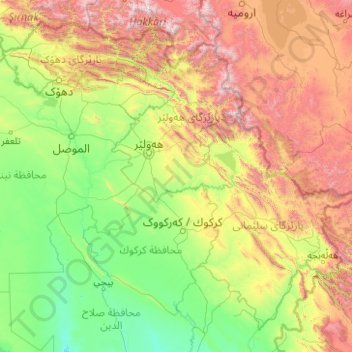
Name: Iraqi Kurdistan Region topographic map, elevation, terrain.
Location: Iraqi Kurdistan Region, Iraq (34.43792 42.34874 37.38067 46.34706)
Average elevation: 811 m
Minimum elevation: 44 m
Maximum elevation: 4,009 m
Other topographic maps
Click on a map to view its topography, its elevation and its terrain.
Nasiriyah
Belgian architect, Jules Tilly, was commissioned to develop a modern urban plan for the city. Tilly introduced a Western-style grid layout, characterised by long, straight, and parallel streets intersecting at right angles, unprecedented in Iraq at the time. This planning approach shaped the city’s…
Average elevation: 5 m
Ranya
Iraq > Sulaymaniyah Governorate
Ranya is located in the Sulaymaniyah Governorate in the Kurdistan Region of Iraq, approximately 70 km northeast of Sulaymaniyah city. It is situated near the Hawraman Mountains and lies at an altitude of about 1,300 meters.
Average elevation: 678 m
Ranya
Iraq > Sulaymaniyah Governorate
Ranya is located in the Sulaymaniyah Governorate in the Kurdistan Region of Iraq, approximately 70 km northeast of Sulaymaniyah city. It is situated near the Hawraman Mountains and lies at an altitude of about 1,300 meters.
Average elevation: 678 m
Hayasi
Iraq > Sulaymaniyah Governorate > Bazian district > Bazyan Subdistrict
Average elevation: 876 m