Geolocate

Feroke topographic map

Click on the map to display elevation.

About this map

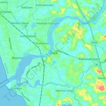
Name: Feroke topographic map, elevation, terrain.

Location: Feroke, Kozhikode, Kerala, 673631, India (11.14254 75.79754 11.22254 75.87754)

Average elevation: 14 m

Minimum elevation: -2 m

Maximum elevation: 71 m

Other topographic maps

Click on a map to view its topography, its elevation and its terrain.

Kakkodi

India > Kerala > Kozhikode > Moottoli

Average elevation: 18 m

Cheruvatta

India > Kerala > Kozhikode > Parambil Bazar

Average elevation: 26 m

Vellimadukunnu

India > Kerala > Kozhikode > Kozhikode

Average elevation: 27 m

Chevarambalam

India > Kerala > Kozhikode > Kozhikode

Average elevation: 23 m

Kuthiravattom

India > Kerala > Kozhikode > Kozhikode > Pottammal

Average elevation: 17 m

Kodampuzha

India > Kerala > Kozhikode > Faroke - Petta

Average elevation: 14 m

Gear up for your next adventure:

🥾Hiking Boot Waterproofing Wax - Maintain the lifespan of your leather trekking boots
🎒Backpack Rain Covers - Universal waterproof covers to protect your gear from downpours
🔋Lithium AA Batteries - Long-lasting power that performs well in cold mountain weather
🗺️Ordnance Survey Maps - Official UK maps for walking and outdoor activities
🍱Food Containers - Reusable containers for outdoor meals

As an Amazon Associate, this site earns from qualifying purchases at no extra cost to you.