Soldano topographic map
Interactive map
Click on the map to display elevation.
About this map
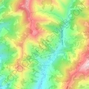
Name: Soldano topographic map, elevation, terrain.
Location: Soldano, Imperia, Liguria, Italy (43.82419 7.64400 43.84491 7.67546)
Average elevation: 250 m
Minimum elevation: 56 m
Maximum elevation: 486 m
Other topographic maps
Click on a map to view its topography, its elevation and its terrain.
Ventimiglia
Italy > Liguria > Imperia > Ventimiglia
Ventimiglia, Imperia, Liguria, Italy
Average elevation: 202 m
Bussana Vecchia
Italy > Liguria > Imperia > Sanremo > Poggio di Sanremo > Bussana Vecchia
Bussana Vecchia, Poggio di Sanremo, Sanremo, Imperia, Liguria, 18011, Italy
Average elevation: 114 m
Arma di Taggia
Arma di Taggia, Taggia, Imperia, Liguria, 18011, Italy
Average elevation: 54 m