Geolocate

Chouteau topographic map

Click on the map to display elevation.

About this map

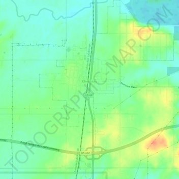
Name: Chouteau topographic map, elevation, terrain.

Location: Chouteau, Mayes County, Oklahoma, United States (36.15955 -95.35982 36.20776 -95.31496)

Average elevation: 190 m

Minimum elevation: 173 m

Maximum elevation: 221 m

Other topographic maps

Click on a map to view its topography, its elevation and its terrain.

Pryor Creek

United States > Oklahoma > Mayes County

Average elevation: 190 m

Lusta

United States > Oklahoma > Mayes County

Average elevation: 190 m

Pryor Creek

United States > Oklahoma > Mayes County

Average elevation: 190 m

Gear up for your next adventure:

🎒Hiking Backpacks - Comfortable backpacks for day hikes and multi-day treks
📢Survival Whistles - Essential safety gear for signaling for help in mountain fog
🦯Walking Poles - Supportive poles for long-distance walking
🎒Hiking Daypacks - Compact backpacks ideal for short hikes and excursions
🧭GPS Trackers - Tracking devices for safety and navigation

As an Amazon Associate, this site earns from qualifying purchases at no extra cost to you.